This is a popular loop hike in the East Hudson Highlands. Our route yesterday took us up/north the Washburn Trail to the summit of Bull Hill (2.3 miles), then down/west on the Notch Trail (1.0 miles), south on the Brook Trail (0.4 miles), and southeast back to the trailhead along the Cornish Trail (1.0 miles). My son Nate and I covered the whole 4.7 miles of this loop in 4 and 1/4 hours, including over half an hour of stops/detours.
From the trailhead parking lot on Rte 9D, opposite Little Stony Point, just north of Cold Spring, we headed up the white (Washburn trail). It was gradual to moderate at first, through ordinary weedy, typical Northeastern woods. 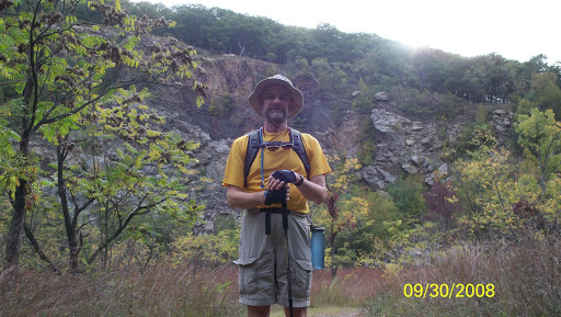
Reaching the old quarry offered us our first impressive views, the flat floor looking like an African savannah, grassy with occasional small sumac trees.
The quarried cliffs, while man-made, were quite spectacular. We detoured off the white trail into the bowl of the quarry and reached a large gravel heap north of our entry point. The gravel heap was dry and flat and seemed like it could be a comfortable place to camp. (Note: there is no approved overnight camping anywhere on this hike, nor to my knowledge, in any of the East Hudson Highlands.)
Nate scrambled 40-50 feet up the quarry face and asserted that he could make it to the top, “with no problem.”
After this 15-20 minute detour, we returned to the white trail that snaked up the rim of the quarry, and soon, off to the right offered dramatic views of the village of Cold Spring and the Hudson River. We felt like we could reach out and move the little houses and cars as if they were Legos. I guess the elevation at this first viewpoint was 300-400 feet.
From here the forest gradually turned into the characteristic mix of the high ground in the Hudson Highlands. Widely spaced chestnut oaks and red oaks with blueberry bushes in the understory dominate, while sugar maples and mountain laurel are also common. It’s a very open feeling, quite attractive and pleasant to walk through. This habitat occurs, not because of the absolute elevation, but in areas that are locally high, somewhat windswept in winter, and with well-drained, drier, rocky soils.
As we ascended some fairly steep sections, once or twice I had to use my hands; otherwise a steep, but wholly walkable, trail.
 We stopped at another viewpoint higher on the left; took a few photos of us and Storm King just across the Hudson.
It’s pointless to describe the views of all the view points on the hike. But, from various places, one can see (proceeding counter-clockwise) NE to South Beacon Mtn, North beyond Breakneck Ridge to the Newburgh Bridge, NW across the Hudson, West to Storm King, West Point, and other mountains, SW across the Hudson River, South – from the village of Cold Spring to Manhattan, and SE across the green hills of Putnam and Westchester counties.
At 1100 feet elevation, the yellow (Undercliff) trail crossed our path. We did not take it, but noted it as a marker. At this junction, we have gained most of the elevation.
After some more relatively steep sections, the trail leveled out, and we could tell we were on top of the ridge (1400 feet). Periodically one could spot viewpoints, both north and south. From one of the north-looking points, we could see all the way to the fire tower on South Beacon Mountain, the one that my 78 year-old neighbor, Dick Warren, climbed up a couple weeks ago. Nate was duly impressed. A little farther on, at a south-facing viewpoint, we settled onto a comfy outcrop and ate lunch. Our 2-liter Camelbaks served us well throughout the hike.
From here on, it was an easy downhill hike, all the way. The white (Washburn) trail led north from the summit, at first following a woods road, but then splitting off to the right as the woods road made larger switchbacks. That is, the white trail cut a straighter path downhill, cutting across the winding woods road a few times.
After some steep downhill going, the Washburn trail ended. To the left was the blue-blazed Notch Trail (our route), while the white-blazed Nelsonville Trails went off to the right. This junction was clearly marked.
The blue trail continued downhill (north) through a thicker forest. It turned left and follows a stream, and entered an area that formerly had been cleared for farms or pastures. Stone walls were everywhere, in places running parallel to each other, where a road must have been. The stream ran in a sharp, straight ravine, frequently lined by stone walls. I suppose it runs in its natural bed, but wonder if the farmers roads and walls might have straightened and deepened the original stream.
The next landmark was a stone foundation of an old house next to the stream.
A few yards away was an ancient sugar maple, still alive, but hollowed out and open on one side. I guessed it was 200 years old, and we both posed inside the hollow. Also picked up a black-and-white feather, which had to be a wing feather of a Pileated Woodpecker, one of whom we heard distincitvely ‘laughing’ in this same area.
The ground levelled off greatly from on home, and we picked up our pace accordingly. At the junction of the red (Brook) trail, a large building, the remains of a dairy farm, stood mutely. Another hiker took our picture in front of the concrete ruins. Apparently other out-buildings lie up (north) the red trail. We headed homeward (south) and noted other evidence: a squat concrete blockhouse next to the creek (good camping in winter?) and a deep cistern farther on.
The yellow (Undercliff) trail intersected our route again, leading invitingly west, uphill to Breakneck Ridge. Nate had “things to do at home,” so we kept moving.
After 0.4 miles, we forked left onto the blue (Cornish) trail, named for a wealthy lead-company magnate, whose estate lies in ruins near this trail. We did not investigate these closely, but as we walked along a concrete-paved roadbed, we marvelled at the very tall and very straight tulip trees. They looked like gigantic, natural telephone poles. Really impressive. I guess that Mr. Cornish had them planted along his private road.
The blue trail went along this concrete road almost back to Route 9D, darting into some scrubby woods for the last stretch.
We arrived at the parking lot at 12:55 – 4 hours 15 minutes after we started. Me? I was ready to go up Breakneck Ridge, but we decided to save that for another time.