It rained steadily through the night. Contemplated the upcoming day (Oct. 8, 2012), my last here. Had to check out Lower Wolfjaw. But the last bit was steeper than Gothics! A rise of 130 meters over 200, while the steepest 400 meters of Gothics had 180 meters. Or so my topo map indicated. Hiking solo, I determined to go only as far as prudent. Got up a little late, but a more practiced morning routine put me on the trail at 7:30. Out to the now-familiar five-way junction and up the yellow-marked Woodsfall Trail.
Snow!
There was snow up high! Last night’s valley rain was mountain snow. How exciting! Some people were making breakfast at Wolfjaw Brook,
Slide Effects
I took a few pictures of the slide’s effect. In the middle, the force of the water stripped the rock raw. On either side, it only ripped out the plants, leaving the dirt. On the edge of the slide lie the up-rooted trees that were thrown to the edge of the stream. Beyond this barrier, the forest is undisturbed. At the bottom of the slide, a massive tangle of crushed trees marked its end. At that point, the weight and friction of the trees and the shallower slope came into play. Physics prevailed, and the water spilled over harmlessly. What a sight it must have been.
I climbed steadily through the black muck, with more and more snow on the branches as I ascended.
I aimed to turn back at 10AM latest, as I still had to pack out and drive 4+ hours. By 9:30 I was at the UWJ-LWJ col. “Half a mile to go … steeper than Gothics … snow on the trees … solo. Not gonna happen,” I thought. But I pushed up into the trees. The steep muddy trail rose, and rose, and rose. So did I. No agoraphobic Gothics open slabs here, just lots of ledges with handy spruces and firs to grab onto. Halle bounded up.
LWJ Summit
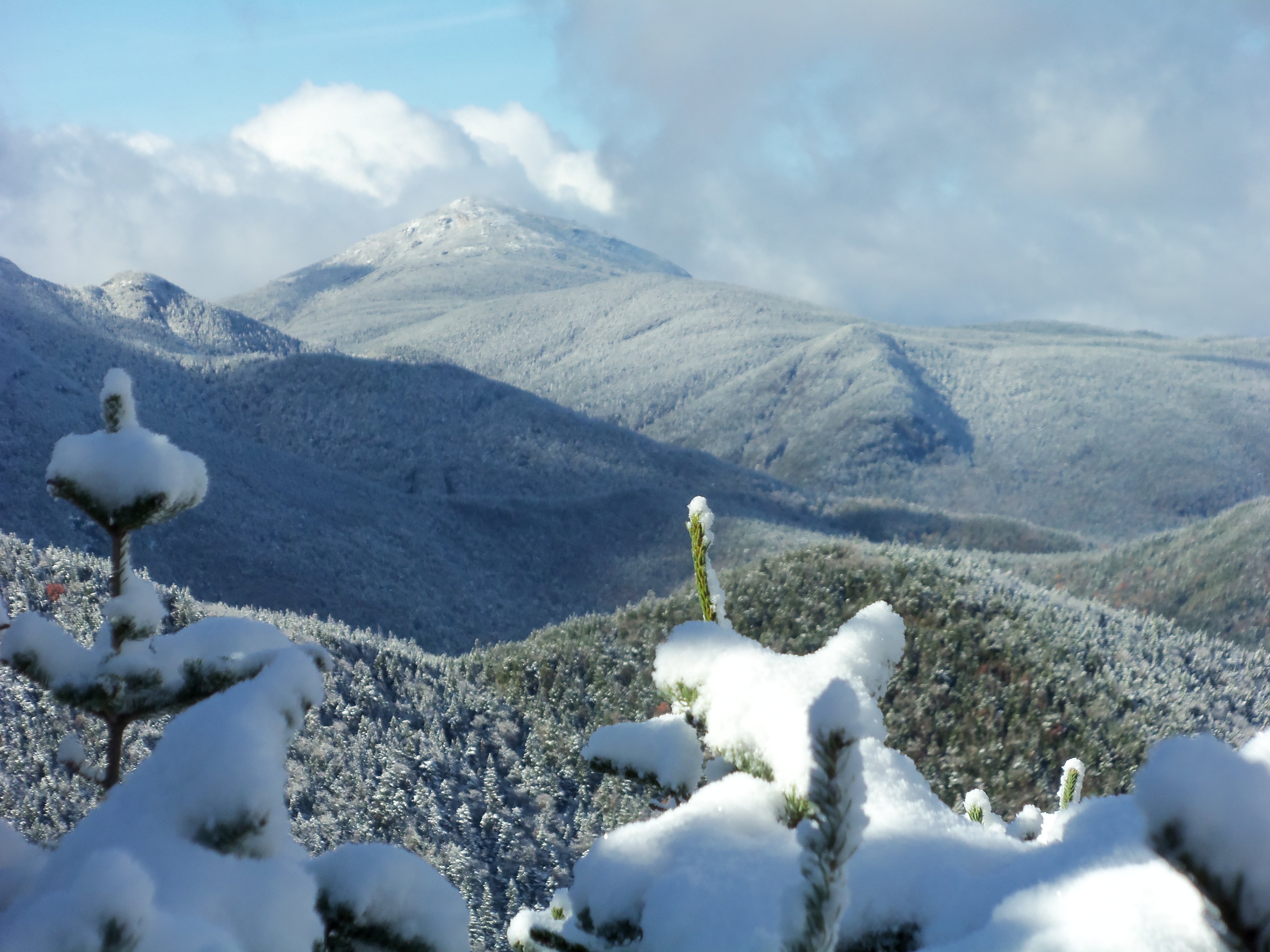
By 10AM I was on the summit, where two inches of snow covered the ground. There were a few views looking west, towards Marcy and Big Slide. What a scene: snow covered branches in the foreground, fall-colored hillsides and snow-clad summits in the distance. Blue and white skies. Had been climbing in just two light layers, and suddenly felt chilled. Donned a fleece and ate some trail mix. It was too cold and snowy to set up the camera for a time-delay shot of me and Halle (my standard peak pic), so I stretched out my arm, and snapped one of myself. A circle of sunlight hit me right between the eyes. The mark of Cain? Explored north, towards St. Huberts, but within a few hundred yards, the trail began to descend, and there were no views. That was it; time to return. Peak #10 for me.
Stowed my poles for the descent, and swung my way down using the trees. What fun! And what a great technique.
Back a JBL just before 1, an hour behind plan. The top of my back had come loose, letting melting snow into it. A few things were a little wet. What an inexpensive lesson – double-check the pack and use the damn pack cover when needed. I spread out and warmed up on JBL’s sunny deck. It was JBL’s last day of the season; the chairs were up on the tables and the floors were swept, but the caretaker sold me some coffee, Clif bars, and patches. (Friggin’ peak patches! Whoever thought that up was an evil genius.)
Heading Out 🙁
Next non-surprise of the day: packing up the tent site took longer than expected. Who would have guessed? Of course, when the tent-packer is an OCD guy who has to wash the dirt off the stakes, things do take some time. All packed up by 3; took a photo of the empty rectangle of flattened leaves, and hit the trail.
The pack must have weighed about 35 pounds, less 8 pounds of food, 3 pounds of water, and a 1 pound tarp/poncho in Halle’s pack. I zipped along the Phelps trail, covering the 3.6 miles back to The Garden in 1.5 hours! 2.4 MPH with a full pack. Making that speed almost took the edge off leaving the High Peaks. Almost. Got home by 10PM.
-

- Trail Marker at JBL, about 7AM
-

- Wolfjaw Brook, scoured by the slide
-

- Halle and Stephen at Wolfjaw Brook and Southside Trail
-

- Uprooted trees and debris piled up at end of Wolfjaw Slide
-

- Backpackers eating breakfast at Wolfjaw Brook
-

- October snow on the Great Range, Adirondacks
-

- Snow on Lower Wolfjaw, October, 2012
-

- Wolfjaws col, trail marker in snow, split for UWJ and LWJ
-

- Upper and Lower Wolfjaws trail junction
-

- Mount Marcy from Lower Wolfjaw, snow on Spruce branches
-

- Big Slide from Lower Wolfjaw, after early snow
-

- Stephen on LWJ summit, Mark of Cain?

-

- Packed up campsite near JBL
-

- Back at The Garden, Phelps trailhead
Now “ADK – 10/46.”